31 December 2017

Wansfell and Wansfell Pike

A New Year’s Eve walk with Angie and Alistair, Andrew and Helen, Anton and Lois (C) but not Lois (S).

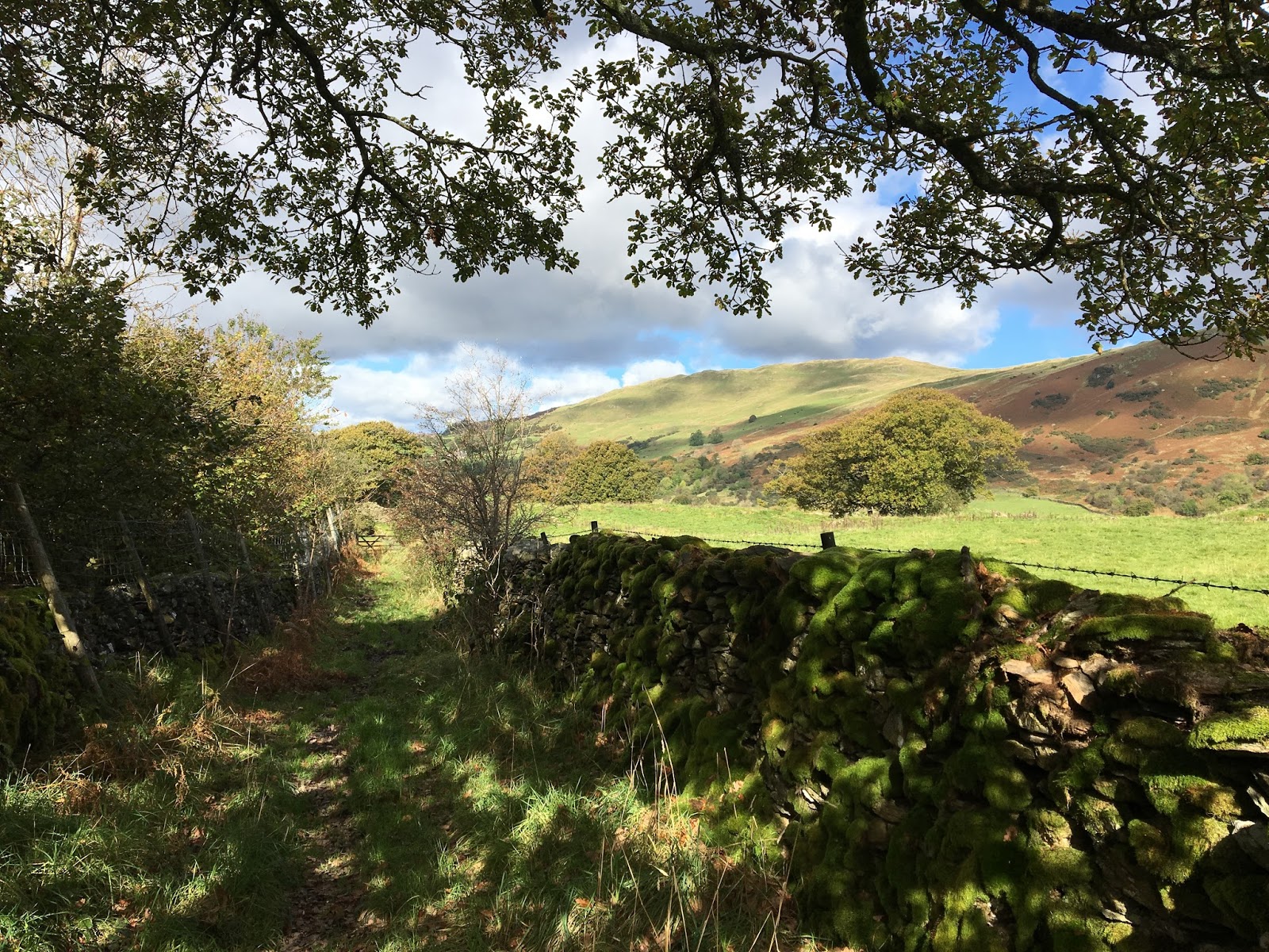
Route: leaving the cars on the top road in Troutbeck and walking north to find Nanny Lane, the walled track ascending onto the fellside. Walking up this until it levels and then on. Ignoring the left turn to Wansfell Pike and staying on the road to a bend and stream where the path has been re-engineered using alluvial material. Towards the end of the track, climbing a stile to the left to find a clear grassy path, initially close to the track but later diverging left and becoming steeper to reach the small cairn of the summit. Then on an undulating path, marshy, along the summit to reach Wansfell Pike. Afterwards descending to the observatory and an initially rising woodland shortcut to find Robin Lane, the main track looping round the bottom of the fell to Troutbeck.

Conditions: cloudy, dark and windy on the top but not starting raining until reaching the cars, again.

Pub: the Watermill Ings for Windermere Brewery Wruff Night.

28 December 2017

Lord's Seat loop


A fine 15km walk on a wintry day, a last-minute change of plan given the ice under foot.

Route: from the cottage walking through the village to cross Whinlatter Pass and climb High How. Then along the clear track east, descending and then ascending but staying roughly level to enter the forestry plantation (Darling How Plantation) via a stile and to venture, for the second time in a month, along a very overgrown forestry track. Emerging onto a clearer track, climbing and then descending swinging right and climbing again to reach a T-junction. Turning left, then straight on at a four-way junction of tracks to head into the head of the valley below Ullister Hill. At a junction (NY 20513 26003) taking a slightly higher overgrown track through trees to emerge onto a saddle to find a well-made path, though under snow, heading left to the summit of Lord's Seat. Then following a largely snowy and frozen ridge past Broom Fell, Widow Hause, Graystones and Kirk Fell and descending towards Lorton. Sadly finding a hypothesised legal re-entry to the village to be a delusion, guiltily crossing fields to gain a tack past Fernwood and then across fields to the pub and then home.

Conditions: cold, icy on roads and snowy under foot but bright and sunny in a brisk wind on the top.

Pub: the Wheatsheaf, Lorton for Jennings Bitter.

27 December 2017

Rannerdale Knotts

A 12km low level stroll/walk on a sunny, frosty day (after several warmer days of heavy rain) with a starting point dictated as much by a fear of icy roads as anything else.

Route: leaving the car at the car park for Grasmoor at Lanthwaite Green Farm and crossing marshy ground to the east to gain the higher lateral path below Grasmoor. Walking part way up an utterly empty Rannerdale to reach the footbridge to cross the stream and return to the pitched path from the road up Rannerdale Knotts. Along the summit with fine views south to Great Gable to descend into Buttermere and to the Bridge Hotel for a beer. Afterwards, taking a flooded path behind the campsite to reach the shore of Crummock Water and thence the rising path over the lower shoulder of Rannerdale Knots and then along the upper shoreline path to the car.

Conditions: cold and bright and sunny. Some ice but not much at these lower levels.

Pub: the Bridge Hotel, Buttermere for Jennings Sneck Lifter.

24 December 2017

Fellbarrow

A short walk in wet and windy conditions with Mark (Sandra languishing ill in bed).

Route: from the cottage by roads to Low Lorton, across the Lorton Low Bridge to take the road, then green lane, up High Bank onto the fellside. After 1.5km, taking a clear track (though not a right of way) to the ruins at Hatteringill. Then steeply uphill by a wall and bearing right to reach Hatteringill Head and deafeningly windy conditions. Following paths and then a line of fence through cotton to the summit of Fellbarrow, stopping to put on over trousers as the rain came on like hail in the high winds. Deciding that it was foolish to continue, descending south and then turning half left on a clear path to meet the path down from Watching Crag, and then across fields to Thackthwaite and then, after a bit of discussion, walking 3km in pouring rain along the road to the Kirkstile Inn, later being rescued by Sandra in her motor.

Conditions: initially a dull grey day giving way to heavy wind and rain.

Pub: the Kirkstile Inn, Loweswater for Cumbrian Legendary Ales No1 IPA and Loweswater Gold, joined by Sandra.

10 December 2017

Brackenthwaite How tootle

A tiny stroll after an impromptu pub lunch.

Route: Leaving the car at the National Trust car park and heading south but above the lakeshore path forcing a right turn and descent to visit the Boat House. Then retracing our steps up hill into the woods swinging left to take a wall side path eventually climbing Brackenthwaite How. Descending west, pausing to look, rather sadly and in vain, for a lost earring made by Mij, and then on by Roger's Steps to the National Trust car park.

Conditions: still, clear but cold.

Pub: (earlier) The Kirkstile Inn, Loweswater  for Cumbrian Legendary Ales’ Loweswater Gold and IPA No 1 (seen for the first time).

9 December 2017

High How to above Spout Force ramble in the dark

A 7km walk at 4pm as the sun set to explore a path visible on Google Earth.

Route: from the cottage walking through the village and up the steep narrow road onto and crossing Whinlatter Pass. Entering right-to-roam land and rising with a zig zag track to the top of High How, exiting the field top right to find a path aiming gently downhill eastwards. (Initially trying for a higher course but turning back.) After a few hundred yards, perhaps foolishly following a signed path diagonally uphill and then across the hillside with no sign of a path in the lessening light. (It would have been better to stick with the more obvious track lower down.) Crossing two streams and in evening darkness entering the forest (deploying a head torch) at a stile and then along a clear but massively overgrown forest track (having to force our way through bushes) until it became a wide, obviously well-used forest road. Following this right round the end of the valley and then down to rejoin the Whinlatter Pass at the Spout Force car park. Down the road, home.

Conditions: a cool night.

Pub? Sadly not. Aldi G&T back at the cottage.

8 December 2017

11km Loughrigg Circuit

An 11 km run on a cold, frosty but sunny winter day.

Route: from the upper Ambleside car park, running 200m on the road towards Grasmere, turning left down a side road to find a path through Rothay Park to cross the River Rothay and turn right onto the Under Loughrigg road. Turning left, before the road re-crosses the river, onto a rising road then shady track to reach views of Rydal Water. Picking the upper, increasingly stony, path, eventually rising to reach the caves and then keeping to higher paths to reach the start of Loughrigg Terrace. Along this and then the higher track, at the end, through trees to reach the summit of Red Bank. Descending, left, to reach a track round the north of Loughrigg Tarn. Part way along taking a footpath on the left across fields to meet a stony walled track rising and turning to circumnavigate the hillside rising to reach a spur and following a grassy path, right, to reach Lily Tarn. Descending on a grassy, muddy path to reach the main track over Loughrigg and thence back over the bridge over the Rothay and back to the start.

Conditions: a cold sunny day though shadowed for the first half of the run. Some ice under foot but not as much as I feared.

Pub: Tweedies Bar, Grasmere for Brew York Brew York and Sadler's Hop Bomb and lunch.

3 December 2017

Head of Kentmere 10km run

A 10km circuit amid mountain scenery, this time from Kentmere itself.

Route: Leaving the car parked in a field at Low Bridge (about 100m before Kentmere Church, £3 all day) and taking a steep road towards Green Quarter. On reaching the main road, and then after about a further 200m, taking a left turn onto Low Lane, a stony bridleway, drier than on the one previous occasion. Along this to rejoin the familiar route at Overend to follow the track to Tongue House. Then by a narrow grassy path, marshy in places, but repaired after flood damage in 2015, to reach the footbridge just south of Kentmere Reservoir. Back along the bridleway, first downhill and then rising above Hartrigg, descending and then, 1km before before Kentmere, turning left on a grassy bridleway uphill and then down to the church and back to the car.

Conditions: cool, still and with some sun.

Pub: The Hawkshead Brewery for WPA and Cumbrian Five Hop (and lunch).

26 November 2017

Pike o' Blisco

A wintry walk with Ian and Steve (no Lois).

Route: leaving the car at the New Dungeon Ghyll National Trust car park (free for members) and taking a muddy path along fields parallel to the river as far as the Old Dungeon Ghyll and then along the road to the campsite and thence up the new-ish zig-zagging engineered path underneath Side Pike to the top of the road pass. Crossing the road and taking a path contouring round the hill to the right and gaining height gradually to meet a path coming more steeply up from lower down the road. Following as it became a paved path into snow to reach the shoulder of Pike o' Blisco. Then through deeper snow, navigating a rock chimney to gain the rocky summit with views over to Crinkle Crags and Bow Fell. Descending a snowy path to Red Tarn and then the clear gravel path over Brown Howe becoming a steep pitched path down to Oxendale, through the farm at Stool End and to the Old Dungeon Ghyll for a beer (or two). Then back along the road to the car.

Conditions: Earlier sun giving way to a cloudy day with a couple of rain showers and a snow shower at the top. Snow under foot at altitude (~400m).

Pub: the Old Dungeon Ghyll for Theakston Old Peculiar.

13 November 2017

Silver Howe

A short 8km walk on a beautifully sunny but bitterly cold day.

Route: leaving the car in the Broadgate Road car park in Grasmere and taking the road (parallel to Easedale Road) towards Allan Bank. Just before it, taking a signed tarmac path round it to the right, becoming a stony track. Following this up a gentle rather indistinct spur of hillside, taking a fork left to cross Wray Gill (OS Grid Ref: NY 32450 07199) a little after an obvious ravine to the left. From the summit, descending south onto a hillocky moorland over Spedding Crag and Dow Bank heading south east. Descending to an obvious lateral path, a bit before the road, near Hammerscar Wood and taking the walled bridleway back to the road and hence the start.

Conditions: bright sun but a bitterly cold northerly wind.

Pub: beforehand, Tweedies Bar for Ilkley Rombald and Fell Bantam. Afterwards, tea and cheese scones in a café on Red Lion Square.

Bell Crags and Ullscarf

A fair 12km walk on a grey autumnal day.

Route: leaving the car (free at the moment to make amends for the tardy repairs post Storm Desmond) at Dobgill car park and heading north along the road. Initially missing the relevant left turn (looking for a missing stile) but back-tracking to find a steep path heading up past Bank Crags to Brown Rigg. Initially biasing to the north / right but correcting to hit the intervening points of higher ground to reach the summit of Bell Crags. Heading south west downhill to find a path parallel to to a fence across a marsh, luckily partly frozen. Climbing up to the left behind Standing Crag and turning right uphill again to follow the fence before turning left on a marshy path to reach the summit. Descending, pathless, initially a little too far from the edge (ie. too far north) but eventually approaching Nab Crags, past the fine Beacon cairn and then over Birk Crag to Harrop Tarn and down the path to Dobgill car park.

Conditions: cool and over partly frozen marshy ground higher up. A grey day.

Pub: Tweedies Bar, Grasmere for Cumbrian Legendary Ales Loweswater Gold and Brew York Big Eagle IPA.

5 November 2017

Carl Side, via Southerndale and the Dodd

A surprisingly arduous 15km walk on a fine, sunny Autumn day.

Route: unable to reach the Dodd Wood car park because of the closure of the A591, parking instead at Dancing Gate and taking a steep muddy forest track (much evidence of use) uphill to find a faint path marked with yellow paint on trees to reach a clearer track coming up from the road and hence reaching a broad muddy forest road leading to a marked route to the Dodd Wood car park. Then joining a clear path north through the woods breaking out of the trees to mount the ridge at Watches and descend to cross the stream. Then taking a grassy track / path to the head of Southerndale and climbing steeply and pathless to the col and on to the summit of Carl Side. Descending as far as White Stones to turn right on a clear lateral path and then heading down hill at a white cairn. Crossing a forestry road at a stile and then taking a track and then well made gravel path leading eventually to the summit. Retracing the route to the stile and continuing 600m down it to where, a year before, there had been a grassy track behind a wooden hut. Now a large muddy track through felled forest led on with no sign of the previous silvern path down-hill. So picking a route through felled trees, across deep but dry mud and using mats of confer branches eventually to exit forestry operations emerging onto the hillside and down to the road close to Millbeck, turning right back to the car.

Conditons: a bright cool sunny day.

Pub: Middle Ruddings, Braithwaite for ** and Barngates Tag Lag but also a free tasting of 7 other beers left over from the Middle Ruddings beer festival which had just finished.

22 October 2017

13 km circuit of Spy Crag and Millrigg Knott

An arduous solitary run in poor conditions.

Route: leaving the Staveley Mill Yard via the foot bridge over the River Kent and taking the muddy path over south east field in the direction of the sewage works. Turning right along the road and then left 400 yards later on a steep drive before crossing a stream below a small waterfall at Side House and rising gently onto the edge of the fellside. Then turning left through Birk Field farm to join the minor road north and following this up the valley on road and track to Ghyll Bank, turning left descending over fields to turn right onto Hall Lane. Gradually gaining altitude again on a stony track diverting onto sodden fields where the bridge over Hall Beck had been removed. At this point the rain and wind rendered sight through spectacles impossible and so shuffling on across marshy paths peering over the spectacles. Taking a grassy path first rising and then descending, and becoming rough under foot and then a stream, through the HP Plantation. A tree having fallen across a gate, climbing a fence and through the fallen tree to regain the path. Back and faster along the road to Ullthwaite Bridge and then, insanely by flooded track and then a quiet road to recross the river at Scroggs Bridge. Along a path to join the start of Hall lane and then back to the footbridge into the Mill Yard.

Conditions: cloudy with wind and rain on higher ground. Sodden under foot.

Pub: the Hawkshead Brewery, Staveley joined by Lois for lunch and for Hawkshead WPA and NZPA.

15 October 2017

King's How

A short walk on a dark but pleasant autumnal Sunday.

Route: Leaving the car at the NT car park for the Bowder Stone and following a sign to it down towards the road and then on a well-made path to the Stone. Proceeding on a quarry track down to the road and along it to a sign and stile on the left. Taking a faint waterlogged path trending upwards and eventually left to climb a faint ridge before heading slightly right to reach a vague saddle. After a 200m taking a path back left to gain the ridge to the summit of King’s How. Onwards, descending a muddy stony path which sometimes became obscured in bracken eventually joining a well-made pitched path slippery with slime and damp leaves and picking our way slowly down to reach the saddle at Brock Bield. Turning left to climb gently before descending towards the road but taking a left-hand path back to the start.

Conditions: dark and cloudy but unseasonably warm.

Pub: the Scafell Hotel, Rosthwaite for Jennings Sneck Lifter.

8 October 2017

Staveley 8km run

A short 7.5km run on a surprisingly sunny autumn Sunday.

Route: exiting the Mill Yard over the footbridge and heading south east across fields to the sewage works and along the road to the track to Side House but turning left after the initial steep section to follow first a road and then a walled track through woods to reach the junction (at SD 48257 98851). Up the valley on road and track to Ghyll Bank turning left descending over fields to cross Hall Road. Here, for the second time, doglegging right-left (rather than left-right) to follow paths across fields (including a surprising uphill section) to Low Elfhowe and then back along a track to Scroggs Farm and the footbridge to the Mill Yard. (Lois again peeled off at Littlewood Farm to take the route directly over (near) Spy Crag to Barley Bridge, turning left below the route to run across fields above the Barley Bridge road and cut down to a farm gate, just opposite the footpath entrance to the Mill Yard.)

Conditions: a dry sunny day though very wet under foot.

Pub: the Hawkshead Brewery, Staveley for lunch, WPA and Cumbrian Five Hop.

30 September 2017

Fellbarrow cycle circuit

A cycle circuit to redeem a couple of pints at the Kirkstile Inn.

Route: from the cottage, crossing the valley to take the Thackthwaite road to the Kirkstile Inn, Loweswater for a couple of pints (the pub suddenly filled by a wedding party) to avoid a rain shower. Then in improving weather but with beer legs climbing and over the pass to Fangs Brow and Mockerkin. For the first time taking a right turn to cycle the higher road via Sosgill and then keeping close to the fell to pass through Brandlingill and thence back to Lorton.

Conditions: improving weather from showers to blue skies and warm autumnal sun.

Pub: the Kirkstile Inn, Loweswater for Cumbrian Legendary Ales Langdale, Esthwaite Bitter, Loweswater Gold and American Invasion.

24 September 2017

Hutton Roof Crags

Rather an unsuccessful ~10km run (given the under foot conditions) but with some points of interest.

Route: leaving the car parked on the side of the road in Hutton Roof and heading south to pick up a footpath through a new development of houses to approach but not reach the right to roam land. Along heading south west under Cockshot Hill on soft ground to reach Crag House. Here the thing to do would have been to join the road but, in false hope, heading across fields eventually to join the road just before a car park. Here entering the right to roam land and slowly ascending the hill first through woods near a substantial wall. Eventually, passing through a small gate to reach the summit. Then on in the rough direction of Farleton Knott on a faint path sometimes across lethal limestone pavements and eventually descending a muddy path to reach the road. Turning right uphill for 200m to reach a signed path back to Hutton Roof with views from the edge of the plateau north. Descending past a rock climber's pitch on a lovely grassy path before hitting nettles and a final descent back to the car.

Conditions: warm, cloudy with occasional hints of sun.

Pub: the Kings Head, Burton for Thwaites Lil Bewdy.

16 September 2017

Keswick railway path and Latrigg

A gentle 10km pootle on an early Autumn day.

Route: leaving the car in the B&B quarter in Keswick and crossing the footbridge into Upper Fitz Park to pick up the railway path and cycle track behind the sports centre (after watching one of the local rabbits clean its inside leg for some considerable time) and heading towards Threlkeld. Following the track along, spotting a couple of deer in the woods on the south side, to the first missing bridge (post-2016 floods) at NY 28849 24432 and then backtracking to follow a temporary footpath north to connect to a balcony path in Brundholme Woods with occasional views across the river. Trending upwards to join a road and following this east to meet a track doubling back to ascend Latrigg, leaving it to follow the edge and reach the summit. Steeply descending slippery grass and then leaves in the woods to join the Cumbria Way and thence back to Keswick.

Conditons: a mild and sunny day with lots of people out and about.

Pub: the Wainwright Inn, Keswick for Fell Brewery Tinderbox IPA and Ulverston Brewery Laughing Gravy.

3 September 2017

Brackenthwaite How run

A 7km Sunday morning run.

Route: leaving the car at the telephone box near the Kirkstile Inn and running past the pub to pick up the track towards Mosedale and Mellbreak and following this up hill towards Mosedale (rather than taking the short cut left hand turn) and then back left along a level grassy path, descending to to Highpark Farm. Along grassy tracks towards the lake but turning left to circuit a mound clockwise and taking a short board walk and grassy track to reach the lake shore further east. Then round the lake to the boat house and uphill into the woods swinging left and then turning right to take a wall side path eventually climbing Brackenthwaite How. Descending west on Roger's Steps to the National Trust car park and back along the road.

Conditions: windy with a threat of rain.

Pub: The Kirkstile Inn for Cumbrian Legendary Ales’ Loweswater Gold

2 September 2017

Whiteside to Whiteless Pike

A 14km linear walk with a bus (Honister Rambler) return trip.

Route: from the cottage taking the Boonbeck road to Scales and then west before turning south on an improving track. At High Swinside Farm briefly joining the road to diverge onto a path to ford Hope Beck and then following along the intake wall on a wet but clear path under the Dodd and Penn. Having crossed Wythe Gill heading diagonally uphill, pathless through bracken following whatever sheep tracks came to hand (not many!). Eventually heading back to the gill and climbing briefly alongside it and then up the higher dry valley on steep tussocky bilberries and mosses to reach the col above Penn and then on to the summit of Whiteside. Then by summit ridge to Hopegill Head, Sand Hill, down to Coledale Hause and then up the enclosed scramble onto Eel Crag to Crag Hill. To Wandope and the down via Whiteless Pike with an hour in the pub before the bus was due (although in fact it was more than half an hour late allowing for ample chat with fellow bus travellers).

Conditons: initially warm and sunny, then cloud with hot sun returning from time to time at the end of the walk.

Pub: the Bridge Hotel, Buttermere for Coniston Bluebird, Mowdy Pale Ale and a pint of grapefruit and soda (!).

26 August 2017

Winder and Arant Haw

An 8km walk with Derek, Naina, Jenny and Simone, Verity, Mark and Hudson B ‘Joss’ Hudson.

Route: leaving the car parked on the main road (A683/4) just short of the Spar and walking north on a footpath to reach Howgill Lane (meeting Verity and Mark). Walking through Lockbank Farm then dog-legging left and right again after about 50m to climb a very steep grassy hillside easing onto a diagonal path. Resisting the temptation to turn left for Winder until reaching a clear, ‘gentle’ path to the summit. Then along a marshy path on the saddle and uphill to Arant Haw. Descending the ridge on a fainter but still obvious path bending left at the bottom to cross a stream. Then heading pathless to try to stay higher than expected to contour round to reach the outward route by Lockbank Farm and back to the car, leaving Verity and Mark on the roadside where we found them.

Conditions: cloudy with sunny spells.

Pub: the Royal Barn, Kirkby Lonsdale for Kirkby Lonsdale Singletrack and a KL mild (not sure of the name).

19 August 2017

Fairfield Horseshoe

A 19km walk on a wet day with Richard Gipps.

Route: Leaving the car in the Rydal Road Ambleside car park and walking past the Golden Rule to take the second left to High Sweden Bridge and then climbing indirectly onto the ridge via a lower path to skirt rocks on the ridge itself and then crossing the wall (for the first time) to take the less used path on its left hand side and avoid the obvious later bog to pass Low Pike, High Pike, Dove Crag, Hart Crag and Fairfield and then down past Great Rigg and Heron Pike. Back through the grounds of Rydal Hall.

Conditions: low cloud and intermittent rain but heavy rain only starting in the last half mile.

Pub: the Golden Rule, Ambleside, for Robinson’s Double Hop and a coke.

12 August 2017

Braithwaite How

A tiny 2km pootle to explore a previously unexperienced view.

Route: leaving the car in the ex-quarry car park near the foot of the Whinlatter Pass and walking downhill to the Hope Memorial Camp (that day aka Kim's Love Shack) and joining a footpath heading north almost as far as the C-road. Backtracking past a gate and then taking a faint but discernible path left and uphill, through a gate, to join the ridge (with a private wood to the left/east) as far as what seemed to be the highest ground. Then on along the ridge losing height to reach the Hope Memorial Camp again, rejoin the road and return to the car.

Conditions: a dry and pleasant evening.

Pub: the Wainwright Inn, Keswick for Fell Brewery Tinderbox IPA.

5 August 2017

Staveley 8km run

A short run after a heavy night in Clapham with Mark, Sandra and a bottle of calvados.

Route: exiting the Mill Yard over the footbridge and heading south east across fields to the sewage works and along the road to the track to Side House. Up the valley on road and track to Ghyll Bank turning left descending over fields to cross Hall Road. Here for the first time doglegging right-left (rather than left-right) to follow paths across fields to Low Elfhowe and then back along a track to Scroggs Farm and the footbridge to the Mill Yard. (Lois peeled off at Littlewood Farm to take the route directly over (near) Spy Crag to Barley Bridge, with a little detour to explore just south of the path.)

Conditions: a dry although cloudy day.

Pub: the Hawkshead Brewery, Staveley for lunch, WPA and Session IPA.

30 July 2017

Hilbre Island

A short morning walk with Steve Jones across sand for a picnic lunch with cans of Punk IPA.

Route: leaving Steve's house in Moels and heading to the coast turning left along Meols parade as far as the lifeboat station. Then diverting onto the beach and slowly heading away from the coast towards the island on wet sand (water resistant boots proving the correct choice). Around 50 yards from the island, stepping carefully across a final stream of water. After watching seals on a distant sand bank, heading right to the end of the island and a former life boat station for a picnic. Then heading directly back towards the shore at West Kirkby. After a beer, returning along the main road.

Conditions: grey skies and windy but fairly warm.

Pub: the West Kirkby Tap, West Kirkby for Bragdy Heavy Industry Electric Mountain, Bad Co. Comfortably Numb, Neptune Brewery Sea Monkeys, Sppitting Feathures Thirst Quencher, Wantsome Fortitude and Blackjack Sticklebract IPA.

24 July 2017

Bowscale tarn

A short stroll with Mike Hornby followed by a swim.

Route: leaving the car on the east side of the road just south of Bowscale farm and taking the track that rises slowly first north and trending west (as the road zigzags east) and following this as it trends upwards and westwards to the tarn. Then walking (possibly the wrong way) clockwise round the tarn on rather wet and marshy ground to find a steeper ingress for a swim. Then heading uphill to find a better track back to the main tarn track.

Conditions: sunny and cloudy. Warm enough to swim despite the cold water.

Pub: the Mill, Mungrisedale for Robinsons Dizzy Blonde, Trooper, and Robohop and lunch, joined by Janet.

23 July 2017

Great Borne, Starling Dodd and Red Pike

A  linear walk half way along the ridge from Ennerdale and then back down the valley

Route: leaving the car at the Ennerdale car park (at the end of the road) and walking back along the road to a stile and then up hill to the east, forking right to make our way to the summit of Bowness Knot via a narrow undulating path. Then back pathless and climbing a fence to gain Brown How and then the main path next to Rake Beck, a scramble in places. On the plateau turning right to the stony summit of Great Borne. Then via a slightly marshy ridge descending and ascending with no one in sight to the summit of Starling Dodd. Then a similar descent and ascent to Red Pike. Descending via a route marked by cairns SW, becoming a clear path only after a few hundred metres, down into Ennerdale. Then 4km along the stony valley road back to the car.

Conditions: initially hot giving way to cloud with a threat of rain (arriving only once we were in the pub).

Pub: the Fox and Hounds Ennerdale Bridge for Cumbrian Legendary Ales Loweswater Gold and Independent Lakeland Brewerie Entente Cordiale.

22 July 2017

High Nook Tarn swim

A stroll to have a swim with Alison Gilchrist as part of her 60 tarns with 60 friends 60th birthday celebration.

Route: leaving the cars at Maggie's Bridge car park (still easy at 11am because of the vile weather) and walking south west on a track to High Nook Farm and then into the comb above and the tarn. Swimming (in T's case, very briefly), dressing, nibbling cake and returning to the car.

Conditions: initially heavy rain giving way to drizzle and then back to light rain.

Pub: the Kirkstile Inn, Loweswater for Cumbrian Legendary Ales American Invasion and Loweswater Gold.

16 July 2017

Fleetwith Pike and Haystacks

A fine 15km day walk from Buttermere.

Route: leaving the car in the National Trust car park before Buttermere and walking into the village and then via Wilkinsyke Farm along the north shore of the lake to the foot of Fleetwith Pike. Ascending the ridge mainly on the edge until, near the top, the route cuts a little in to the right, with increasing views back north to Scotland. From the summit descending south-east on a marshy path to quarry works and then down to a stream (which might be difficult in flood) to find a paved and marked route towards Haystacks. Under Green Crag taking a slightly higher path to the right rejoining the main route before the Innominate Tarn and then forking right to stand on all four possible summits. Descending to Scarth Gap and then along the south side of the lake back, via the Bridge Hotel, the car.

Conditions: a warm sunny day.

Pub: the Bridge Hotel, Buttermere for Tractor Shed Mowdy, and Heskett Newmarket Haystacks.

15 July 2017

Brackenthwaite Hows pootle

A 6km run to redeem an inactive rainy day.

Route: leaving the car at the National Trust car park and zigzagging south and then north to pick up the small path up Roger’s Steps to the summit plateau of Brackenthwaite Hows. Descending south and picking up, for the first time, a path within the wood by its eastern wall to join the small path descending to the boat house. Thence round the lake to Highpark Farm and round the end of Mellbreak before descending to the Kirkstile Inn and then back along the road.

Conditions: grey and windy and threatening rain but not cold.

Pub: the Kirkstile Inn, for Cumbrian Legendary Ales American Invasion and Loweswater Gold.

1 July 2017

Linton Falls to Burnsall and back

A 10km walk after lunch with Robin, Virginia, Jeff and Susie at the Angel, Hetton to continue Robin’s birthday celebrations.

Route: leaving the car at the Linton Falls car park (£4.50 all day) and heading to the viewing spot for the falls. Crossing a wide spanned footbridge and then turning right to pick up a riverside footpath, the route of the Dales Way, pausing to view the stepping stones to the church at Linton. After 3km spurning stepping stones to cross back over the river on a pedestrian suspension bridge and, with view of Loup Scar, continuing south east to Burnsall for a half pint at the pub. At this point, the party dividing and we, with Robin and Virginia, returning via footpaths across lower slopes to Thorpe and then along the road to a right turn down an overgrown green walled track to reach the B6160 and then a diagonal grassy track back to the start.

Conditions: initially sunny and warm but windy and later cooler with a threat of fine rain.

Pub: the Red Lion, Burnsall for Bradfield Farmer’s Blonde and Ilkley Brewery Mary Jane

24 June 2017

Red Pike (Buttermere)

A walk on an improving day with Jake and his father Lisle.

Route: leaving the car at the NT car park (hence free) and taking the lakeside path to the diagonal pitched path past Old Burtness, out of the wood and onto the still steep hillside to reach Bleaberry Tarn and  then past the pitching to a loose steep path into cloud before the summit. Attempting to take the NW path down Lincombe Edge but becoming disorientated in cloud and finding ourselves further west than intended and finding the turn right at a T-junction down fenceposts counter-intuitive. This, however, turning out to be correct, emerging from the cloud on a broad shoulder before descending on an obvious path by Scale Beck, washed away in part, (while being overtaken by the 3 leading runners in the Darren Holloway Memorial Fell Race on their way over to Mellbreak and back to Loweswater) and then along a path above Crummock Water and then back to Buttermere.

Conditions: dark threatening cloud over head and cloud shrouding the summit (hence navigational confusion) but sunny when back at the pub.

Pub: the Bridge Hotel, Buttermere, for Jennings Cocker Hoop.

18 June 2017

Cycle to Staveley via Grayrigg

A surprising scenic 30km ride followed by a swim in Potter Tarn and a return trip.

Route: from home along Paddy Lane but turning right half way along with the WtoW route to Kiln Head and then turning north to Grayrigg. Then on to Whinfell Tarn and Haveriggs and taking the quiet road to Watchgate to cross the River Sprint at Garnett Bridge. Then via Potter Fell High Road to Staveley. After lunch at the Beer Hall and a spell at the Staveley Carnival, cycling round Piked Howe, leaving the bikes and walking to Potter Tarn for a Jo Cox memorial swimming event with Alison Gilchrist. Then cycling home.

Conditions: a blisteringly hot sunny day.

Pub: Pub: the Hawkshead Brewery Beer Hall, Staveley, for Hawkshead Session IPA, WPA and lunch.

12 June 2017

Tunbridge Wells to Lewes (cycle holiday)

Day 4 of the Garden Ring cycle holiday with Ian and Steve.

Route: leaving Tunbridge Wells on an initially busy road rising out of town before turning left and descending to the miniature bouldering park at High Rocks. Then on (tiring) undulating roads through Eridge Green and Rotherfield to reach Mayfield for coffee at the rather lovely Pink Cabbage Produce Co. Climbing a final series of hills to reach Heathfield and then descending to the ex-railway line which forms the Sustrans Cuckoo Trail and speeding along this to Polegate for lunch. Afterwards, crossing the Downs via Jevington to Friston, descending a windy A259 and then turning right to reach Alfriston for tea with Emma and Nathan and Alison (at Badgers Tea Room) and handing over our panniers for a lift back to Lewes. On on a mix of country roads and cycle paths by main roads to the Snowdrop Inn for a final half and then home to Steve’s house.

Conditions: starting cloudy but becoming sunnier in the afternoon.

Pubs: the Dinkum, Polegate for Harveys Sussex Best Bitter, Olympia and Copperwheat. The Snowdrop, Cliffe for 360 degree Brewing APA and Downland Brewery Cloud Physics.

11 June 2017

Canterbury to Tunbridge Wells (cycle holiday)

Day 3 of the Garden Ring cycle holiday with Ian and Steve.

Route: leaving Canterbury and almost immediately heading uphill on shady narrow country roads to enjoy occasional views before reaching the edge of a hillside near Warren Street and descending for coffee at Lenham. Then a swift ride to the pub at Frittenden. Afterwards, continuing climbs and descents to reach Bewl Water and tea followed by another climb and descent and climb again to Tunbridge Wells

Conditions: a cloudier day though still warm.

Pubs: the Bell and Jorrock, Frittenden for Tonbridge Countryman. The Sussex Arms, Tunbridge Wells, for Timothy Taylor Landlord, Adnams Mosaic, Longman American Pale Ale and Tiny Rebel Cwtch.